
The Starved rock state park is a perfect package for tourists. It offers hiking trails along with nature, Magnificent views of the Illinois River, and recreational opportunities. Starved Rock State Park has been voted as the number one attraction in the state of Illinois and is situated at the Illinois river bank. I didn’t know about this place until one of our friends asked us to join them on the trip. It has impressive waterfalls that are seasonal or active after rain. It was so much fun hiking in the starved rock state park.
How to get there
Chicago O’hare international airport is the most accessible airport to reach with excellent connectivity in terms of international and domestic flights. The Starved rock state park will be almost 1 hour, and 45 mins drive with moderate traffic.
You can also take a flight to Milwaukee General Mitchell International Airport or Dane county regional airport for a cheaper flight. From these airports, it will be more or less than 2 and a half hours to reach there.
You can easily find rentals from the airport and drive to Starved Rock state park.
Tip to explore Starved rock state park
- First and foremost thing, reach early as possible around 9 AM. As the day will pass on, it will get crowded. And challenging to walk around and go to the spot.
- If you are planning to walk on a hiking trail, then wear hiking shoes which comfortable for a walk.
- Don’t forget to carry a hiking bag. Here are some hiking essentials you can add-in.
- There is a parking lot near the visitor center, and trails start just behind the visitor center.
- If you are planning to spend just one day and cover the whole park, then stay energetic because the trail has plenty amount of steps for up and down, especially on the bluff trail.
- I would suggest you spare at least 2 days to get the best out of it.
Here is the address for the visitor center Starved Rock State Park Visitor Center, 2668 East 873 Road, Oglesby, IL 61348
The history behind Starved Rock State Park
I was wondering why the name of the park is starved because it indicates something related to hunger. My guess was right. When I was looking at their website, I learned the name of the park was derived from a Native American legend. According to the website, In the 1760s, Chief Pontiac of the Ottawa tribe was attending a tribal council meeting. At this council of Illinois and the Pottawatomie, and Illinois-Peoria brave stabbed to Chief Pontiac. Vengeance arose in Pontiac’s followers, and it leads to a great battle. Illinois was fearing death and took refuge on the great rock. After many days, remaining Illinois, died of starvation, giving this historic park its name – Starved Rock.
Explore Starved rock state park
Before you head on a hiking adventure, I will definitely recommend you to stop by a visitor center and grab a map. Also, talk to the ranger about trail conditions, especially in winter. The starved rock state park is open all year round, but be prepared for cautions according to the weather.
When we visited there was unexpected rain momentarily, so we bought ponchos from the souvenir shop beside the visitor center.
Trolley Ride
This park offers a chance to explore its beauty to everyone. Sit back, relax, and enjoy the view at your comfort. They offer various trolley tours like historic trolley, winter wildlife trolley, Eagle trolley, waterfall & canyon, and fall colors trolley tour. You can check the schedule and pricing on Starved Rock State Park. For trolley, tour reservations are required, which can be done online or by phone.

Hiking
When I started to write about this most famous state park of Illinois, I was literally running out of words. The beauty of canyons and waterfalls, which I experienced was beyond my expectations. I really didn’t know how to describe it in words. My words don’t do justice to it, but still, I tried my best.
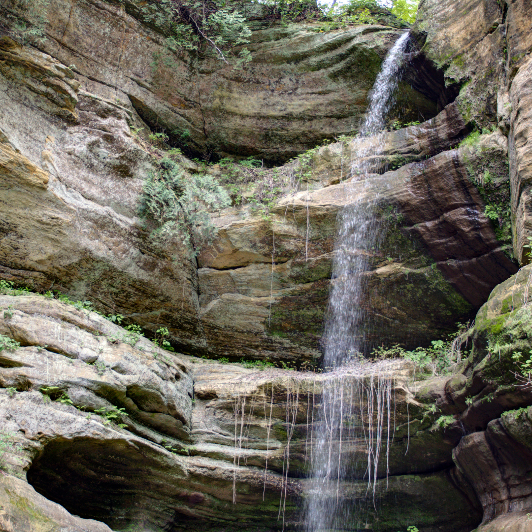
The total length of the trail is 13 miles. And it has 18 canyons formed by glacial melt-water and stream erosion. The park is known for its canyons and waterfalls. Basically, there are three trails Bluff trail, River trail, and interconnecting trail.
We started our hike from the visitor center and took an interconnecting trail to hike 0.3 miles to starved rock. This trail goes around the starved rock and comes back to an intersection where you can choose to go to Aurora, french, or Pontiac canyon.
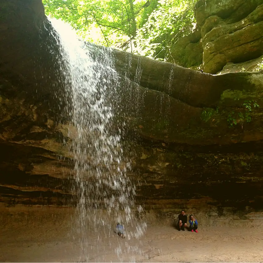
Wild Cat Canyon
Aurora Canyon is on the opposite side of the visitor center, and this trail leads to Sac canyon, Kickapoo canyon, and St. Louis canyon.
From the French canyon, we head to the wildcat canyon, which is one of the popular canyons of the park. We continued on the bluff trail and enjoyed the beauty of Basswood canyon and Lonetree Canyon. From there, we took the stairs to the riverside trail. Follow the riverside trail towards the Tonti canyon. In bad weather, the authority closed the trail to Tonti canyon. In that case, you can go to Lasalle Canyon. From the visitor center to the Lasalle canyon is a 2-mile hike one way.
Riverside Trail
From Lasalle canyon, we returned to the parking lot through the riverside trail as we still need to check out overlook points on the trail. There are four overlooks on this trail, which gives a beautiful view of the Illinois River.
Eagle cliff overlook is the closest point to see the dam, but Lover’s leap overlook gives a close-up look of the dam from the other side of the river. Beehive overlook and sandstone overlook gives a scenic view of the Illinois River. Through Pontiac canyon, we ended up at the visitor center. This whole 4-mile hike took 7 hours for us, including spending at least 10-20 mins at each canyon

